In recent years, the Prairies have seen bigger swings in climate conditions — very wet years followed by very dry ones. That makes an already unpredictable landscape even harder to forecast, with real consequences for flood preparedness and water quality.
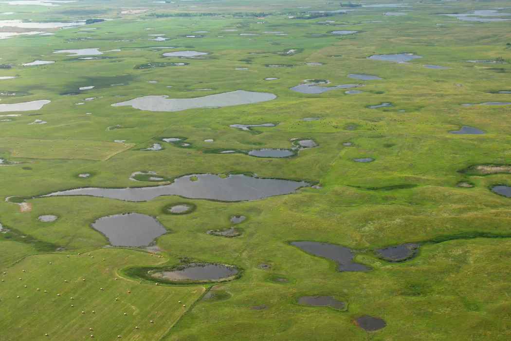
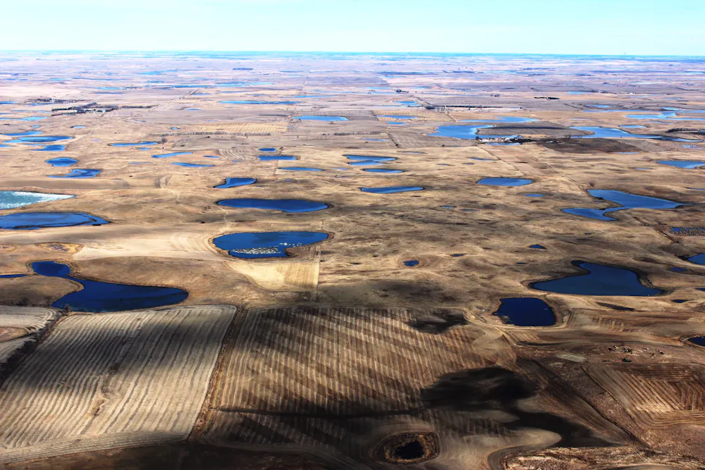
The challenge is the landscape itself. Much of the Canadian Prairies sit within the Prairie Pothole Region, a landscape dotted with millions of shallow wetlands and depressions. Water doesn’t simply run downhill into a stream, it is stored first. Then, once enough wetlands fill, water begins to spill from one to the next, and only after that does it connect into channels.
Why does this matter now? In a landscape that can flip quickly from soaking up water to connecting it downstream, small differences in how wet the wetlands are can be the difference between a manageable spring season and a damaging flood. The problem is that in many watersheds, we don’t have the local measurements needed to tell whether wetlands are still retaining water or are close to connecting and releasing it downstream.
Across the Canadian Prairies — from southern Alberta through Saskatchewan to Manitoba — streamflow monitoring is sparse, and many watersheds have no gauges. These devices measure water levels and flow rates in rivers and streams, and, less commonly, water levels in wetlands.
Communities in the Red River Basin, the Assiniboine watershed and rural municipalities throughout the Prairie provinces often have limited warning when water conditions shift. This affects flood preparedness, agricultural water management and our understanding of how water is stored and moves through Prairie landscapes, with implications for water quality.
What we see again and again is this: the same rainfall or snowmelt can produce very different streamflow, depending on how much water is already sitting in the network of wetlands.
But understanding the mechanism is not the same as being able to make reliable predictions in an unmeasured watershed. That’s the core problem my colleagues and I tackled in our new study: how to merge Prairie Pothole physics with modern artificial intelligence (AI) so we can estimate both streamflow and wetland water storage in places where measurements are not available.
Predicting streamflow
I’ve spent years working on fill–spill–connection behaviour and why it makes Prairie streamflow so hard to predict. I’ve also studied what happens when wetlands are drained or changed — how some wetlands do a much better job than others at reducing floods, and how losing wetlands can make it harder for the landscape to hold onto water during dry spells.
Many people think predicting streamflow is mostly about inputs: rainfall and, in the Prairie Pothole Region, snowmelt. If a storm is big enough — or if spring melt is large — rivers rise. In many landscapes, that intuition is reasonable. In Prairie Pothole landscapes, it often fails.
Here, a large fraction of rain and snowmelt goes into storage first. Early in spring, much of the meltwater fills wetlands rather than running off directly. Later, after enough filling, pathways “switch on” and water begins moving into channels. The same rain event can produce very different streamflow depending on how full the wetland network already is.
The hard part is determining how full that network is. It isn’t directly observable from standard weather data. Because the system behaves in a threshold-like way, where small changes in how much water is stored in wetlands can trigger large changes in runoff, the Prairie Pothole Region is among the hardest places to predict streamflow.
Previous approaches have each faced limitations. Modelling every wetland in detail requires maps and information that often don’t exist at the scale needed. Relying on AI alone can also struggle, because the key factor — how full the wetlands are — isn’t directly visible in the usual input data.
Combining physics with AI
In our new study, we built a model that embeds fill–spill–connection physics directly into an AI framework, rather than asking AI to learn this behaviour from data alone. Fill–spill–connection physics describes how water fills wetlands, spills once they are full and connects to downstream rivers and streams.
It depends on a few key parameters: how much water the pothole network can hold before spilling, and how quickly the connected area expands as the landscape wets up. We use AI to learn how these parameters vary across the region, shaped by soils, climate and topography. Instead of treating each watershed as a totally separate problem, the model learns regional patterns that can be applied to watersheds without streamflow records.
We tested the approach across 98 watersheds spanning the Prairie Pothole Region. In tests designed to mimic unmeasured watersheds, our model predicted streamflow more reliably than AI models that do not represent these physical processes.
Importantly, it also captured wetland storage dynamics: the year-to-year fluctuations in how much water the pothole network holds. When we compared that storage signal with satellite-based wetland inundation maps, the year-to-year ups and downs lined up well.
What this changes
(Flickr/USFWS Mountain-Prairie), CC BY
Being able to estimate both flow behaviour and wetland water storage in these watersheds opens practical possibilities.
First, it can support flood preparedness by helping identify when a watershed is getting close to the point where wetlands start to connect and release water downstream. In the Prairie Pothole Region, flood risk isn’t only about how much rain falls in a day. It’s also about whether wetlands are full enough that new water will be routed, not stored.
Second, it can help describe how watersheds differ across the Prairies: which areas tend to hold onto water longer, which connect more easily and where streamflow is likely to be more variable from year to year. That kind of regional picture is difficult to build when monitoring is sparse.
Third, it offers a bridge between process understanding and modern data-driven tools. This is not AI replacing hydrology, it is hydrology making AI more reliable in places where the mechanism matters.
For Prairie communities and land managers working in watersheds without gauges, better predictions of when water will be stored — and when it will connect and flow — would be a practical step forward.
![]()
Ali Ameli receives funding from the Natural Sciences and Engineering Research Council of Canada.